|
 Home
> General Information
> Geography and Climate Home
> General Information
> Geography and Climate
Introduction | Facts |
Travel Essentials | Geography and Climate |
Language
Culture and Religion |
Economy and Government |
Night Life |
Sports
Lebanon is a small country of only 10,452 sq Km.
From north to south, it extends 217 km and from east to west, it spans 80 km at
its widest point. The country is bounded by Syria on both the north and east (over 375 Km)
and by Israel on the south (over 79 Km).
The country can be divided in four different
regions.
|
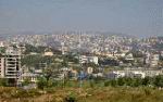
(1) The coastline: This small piece
of land between the Mediterranean and the mountains is where most of the
population is living. Major cities and towns like Beirut, Tripoli, Byblos,
Saida, Tyre are situated along the coast. The density of the population is very
high from Beirut to the town of Byblos. The climate is sub-tropical, there is
no frost. Winters are humid and mild; summers are dry and very hot. Agriculture
in this area consists mainly banana plantation especially in the south and Olive groves in the north. |
|
 |
|
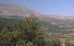
(2) The mountains: Next to the
narrow coast line a chain of mountains call Mont-Lebanon crosses the country.
The highest point is 3090 meters above the sea. Plantation and climate depend
of the ground elevation. You find olive, orange and citrus groves; apple and
pear trees. During the summer, many Lebanese spend the weekend in the mountains
to avoid summer heat. During winter, the mountains are a paradise for all
wintersports. |
|
 |
|
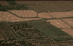
(3) The Bekaa Valley: this fertile
area is a farming region. Mediterranean climate with cold winters and hot dry
summers permits tomato, potato, bean, and grapefruit plantations. Rain fall is
limited throughout the year.
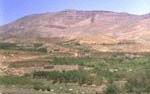
(4) L'anti-Lebanon: This arid chain
of mountains is the natural frontier with Syria. |
|
 |
|
 |
The climate varies from a Mediterranean-type
subtropical climate along the coast and in the Bekaa Valley to a generally cool
one in the upper mountains. Summers are hot and dry; winters are mild and
humid. Frost is rare at lower elevations. The mean temperature in the lowlands
is 26.7° C (80° F) in summer and 10° C (50° F) in winter. The
mountainous region is somewhat cooler. Annual precipitation, occurring mainly
in winter, is 889 mm (35 in) along the coast, 635 mm (25 in) or less in the
Bekaa Valley, and more than 1270 mm (more than 50 in) in the mountains. In some
spring months, one can ski in the mountains and swim on the coast, both in the
same day.
Introduction | Facts |
Travel Essentials | Geography and Climate |
Language
Culture and Religion |
Economy and Government |
Night Life |
Sports
|